Thursday, October 11, 2012

Photography Day


We knew it would be a grey day as we started out, still dark, at 7 a.m. to head north with our cameras, coffee, and delicious coffee cake.  As dawn lit the sky, we knew it would be a chilly and overcast morning. 

Our first stop was at the Point Cabrillo Lighthouse, which we were surprised to see was wrapped in plastic for renovations.  Although the lovely lamp gleamed with its many facets, the picture-taking opportunities were limited because of the rennovations, but the setting is lovely.


We pushed on, wanting to stop at the Pudding Creek Trestle Bridge to see it in the emerging light.  The trestle is laced with lichens, giving splashes of orange on the slate grey pilings, with the estuary flowing quietly beneath it, to spill out the mouth of Pudding Creek into the crashing surf.

The estuary was filled with floating algae and foam, with birds swiming, wading, or moving in the sand along the water's edge.  A snowy egret slowly waded along, strking his beak into the water and quickly gulping down the catch, many of them, as we watched.

No one else was on the beach, and only one young couple strolled across the bridge itself as we moved across the sand, snapping our pictures.  Once, while we studied the bridge, a juvenile gull in turn was studying us before finally running across the sand toward the water.

The sand hill we climbed was steep, but on the other side was a flat beach with dried algae draping across the driftwood, all leading to the wide mouth of the river.  Past the river, to the west under the leaden sky, were rocks with high surf crashing up and over the outcrops, looking like small waterfalls in the grey seas.


Our next stop a few miles north was at the lake at MacKerricher State Park, where a gaggle of geese swam among the mallards and the coots.  Three mallards thought we brought food, and quicky emerged from the water to run up to us.  Two of them were particularly enthusiastic as they encircled our feet, and hoped we had something in our pockets.


The iceplant that covers much of the sand dunes, while invasive, is lovely as it slowly turns crimson with the chill evenings. 


We moved to the parking area by the Boardwalk, where another car or two were parked, but still the morning was quiet with only an occasional jogger or other early morning nature lover on the trails.  The Boardwalk led us to oversee churning waters, some with streams of foam so thick it looked like rolls of cream on the grey sea, others with more cascading waterfalls, and solitary birds flying by.


Our next stop was trying to find vistas near Westport, and beyond. 


At one we met a delightful man from the Southern US on a trek across the Nation, and today was heading south to cross the Golden Gate Bridge.  We hope he enjoyed the coffee cake.  Lovely seascapes--more monchromatic than a sunny day would provide--abounded.

But the unusual juxtaposition, such as a coil of rusty cable and dried wild flowers, still make for intriguing photographs.


We headed back to Russian Gulch State Park, where the photographc opportunities were terrific--whether it was the reflections in the small stream, golden leaves floating in a calm eddy,  the interesting bark of a tree, or the reflected silhouettes of trees in the sea. 


We ended the day a little after noon, and headed home.

Thursday, September 27, 2012

All About Water In The Desert


We started off early, heading toward Hagerman to view the Hagerman Fossil Beds where the famous Hagerman Horse and other Holocene and Pliocene fossils have been discovered.  But, it seemed, today the main focus would be on water. 
We first stopped at the Malab Gorge State Park, where an exquisite narrow canyon has been carved by the torrents of a spring-fed creek.  A pedestrian bridge crosses the gorge revealing not only the gushing waterfalls cascading down a narrows, but also the turbulent flow of the Devils Washbowl just under the bridge.   
The sound of the cascading water is thunderous, and the canyon is truly beautiful--this spot was the highlight of the day, and not to be missed if you are passing through the area.
Trails and overlooks provide unique views of the canyon, birds, and habitat.
Restrooms are clean and the picnic area--wide and grassy with many shade trees--is lovely.
Below is a picture of the turbulent washbowl taken from the pedestrian bridge.
 
 
This canyon, like the snake, has also been dammed for power and irrigation of the desert lands around, where less than 10 inches of rain is received every year.  Still, below the surface, tremendous groundwater basins exist, and these pop out of the barren lava, cascading down into the canyons as lovely waterfalls.  Malab Creek winds its way to empty into the Snake River, where even larger and more powerful dams are administered by Idaho Water & Power.  Still, seeing placid reservoirs above the dam did not prepare us for the many natural ponds and creeks which crisscross the plateau. 
Our next stop was at the Hagerman Fossil Beds Visitor Center.  Having seen the John Day Fossil Beds visitor center, we were disappointed with the small size of Hagerman's, plus the dearth of informative stops within the Monument.  Since it is described as "temporary" perhaps plans for a more informative visitor center will one day become fact. The fossil Hagerman Horse is terrific and worth the stop.  Be sure to watch the short film.  The monument has an interesting overlook of the deep wagon wheel marks of the Emigrant Trail and it is easy to put yourself back into the footsteps of the early and mid 1800s as pioneers moved west.  The Hagerman Horse from Hagerman is the largest sample of this extinct species from one locality. Over two hundred individuals were explored and recovered by the Smithsonian Institute, including complete skeletons. They were about the size of the present day Arabian horse, and had a single toe (hoof). Despite the popular use of the name, the Hagerman Horse is actually more closely related to the zebras, apparently.
 
We explored the Monument, then continued on our way.  Waterfowl are plentiful, and every farm (which tend to be large with homes remote from neighbors) had a natural “water feature” gurgling through their yard.

The most amazing site was a series of springs cascading down the basalt cliffs of the Snake River Canyon in a horizontal plane at a place known as a 1000 Springs.  So much water coming out of the dark volcanic rock was surprising, and must be even more beautiful in the spring months.


On the more mundane level, we saw a balancing rock similar to that seen in Arches NP, but here is no red sandstone.  Here is dark volcanic basalt.  Yet the rock balances precariously at the top of the canyon.


We also stopped a a nice rest area for our picnic lunch, and all around the base of four dead trees were abundant white mushrooms.  The only place they grew were under the dead trees.  Later, we stopped back again to use the rest stop, and the maintenance crew had mowed the lawn.  Not a trace of the mushrooms, which had numbered in the hundreds, were left—not even a chopped white fragment which must have been sucked into the lawn mower bag.  
 
Reminder--if you are stopping at the Twin Falls Idaho KOA, be sure to select a site BEHIND the office, as it will be quieter--many trucks use HWY93.

Wednesday, September 26, 2012

Craters of the Moon & Twin Falls


Liz and I pushed on from our Good Sam Village of the Trees  campground in Idaho--the grass expanses were the best of any commercial campground we had yet been in.   The restrooms need updating, as they are old and the toilet stalls are small, but Liz used the shower and said it was good.  The laundry facilities were good.  Everything was clean.

We talked with Helen today and she is getting new medicine, and hopes that she will improve more rapidly now that she is at home.  We hope so too, but know she would have really liked the area we drove through today, and would have loved the Craters of the Moon campground.  It is dry camping, but the restrroms are equiped with electricity and outlets.  The campsites are very nice, mostly with some privacy from your neighbor, and the erie beauty of the area is lovely.  The expanse of black lava is so immense that it can be seen from space, and the trail guide shows a space image of the area.  You can see most of the formations by road, but a good deal of the monument requires permit aaproval to access, as past tourism has mnanaged to damage the fragile lava terrain.

We drove the loop drive, stopping and taking short walks along th way on well prepared and maintained trails.  One area was right along the road and showed the thick lava river flow that looked all the world like a black  glacier frozen in place.  It was here that we also had a strong cell signal--there is no service in the campground or at the visitor center.  We checked in with Julie and Helen and all is well.

 
Another stop was at the end of the loop, where trails led to the spatter cones, large cone shaped lava depoits that spit-and-spat from a vent until they formed the cone shape seen today.


The whole day was`overcast with occasional showers, and it sprinkled a couple of times in the night.  Today we left and headed towatd Twin Falls where we will stay two nights in the KOA there and explore the area. 


We already started by stopping at the most excellent visitor center right on the Snake River next to the famous Perrine Bridge. A lovely walking trail goes along the canyon, and art work such as the staute above, is placed along the trail.  Overlooks of the famous Perrine Bridge are on both sides of the bridge.   People from all over the world come to leap off the bridge and sail up the Snake canyon to land at the river's edge.  One group from Australia (had to be be, Brad...) was preparing to jump just as we got there, and I was able to catch a good sequence of them preparing to leap, lowering a sail, gliding down the canyon, and landing:


He apparently czme right down where he was supposed to, because his buddy also lept from the bridge, and he too sailed down to land beside him.  I captured a few photos of his buddy dangling over the rive--lucky photos as I was using a telephoto zoom for all of these:


After leaving the Perrine Bridge, we traveled upriver to the Shoshone Falls, which upon first discovery were so magnificent that the mist rising into the air above the canyon from the crashing falls could be seen for miles away.  Around theturn of the last century, a opower plant was built which harnessed the flows, but the falls are still impressive in spring when they are said to rival the Niagra.  Today, in the autumn, the falls have dwindled and do not cascade across their entire broad reach, but drop in a series of ribbons, one of which is quite beautiful:


The presence of these dams on the Snake River has allowed massive iorrigation of the desert in this area--with bountiful production of potatoes, corn, alfalfa, and more.  The dams are controversial in this day, because of the impact on the migratory fish that come up the Columbia River and into the Snake River system.

Upon returning to our campground, afer stopping at an O'Reilly's for some 40 amp fuses, I fixed the trailer by replacing the pair of blown fuses.  All is working fine now.  The battery is being charged by the shore line again.

Monday, September 24, 2012

Reverse Plan to Salt Lake City

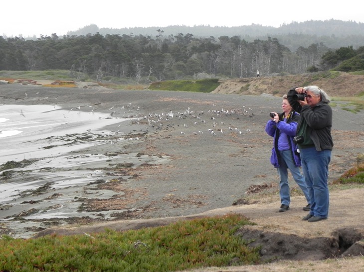
Saturday is our last day at the Arches and Canyonlands.  Because we still have good RV power, we leave for a planned day of exploration.  Helen's sciatica is still very painful, especially in the morning and if she lets her pain medications lapse.  She cannot take the walks with Liz and I, but she does get out at the stops and has some good photo opportunities. 

For example, we stopped along the road to photograph at differing points and light/shadows the formation kpwn as the Three  Gossips.  These indeed look like three woman from the nineteenth century, gathered in a group and stopped as they share information. Today is early morning light, and the gosspis are strinking, yet as we travel around them on the road, stopping for more pictures, the light changes and they assume different shapes.


Another stop where Helen had good views from just the parking area was at Devils Garden, where we watched two young men climb on up the steep and sheer towers of red sandstone, while down below a toddler played around the legs of his pregnant mother, who stared upward at the climbers.  The picture at the left is just one of the formations in the Devil's Gardens.

We also stopped at Delicate Arch, one of the prettiest arches in the park.  It is along the skyline, but a strenuous hike takes you right to the arch.  The viewing area is an easy walk, and Liz and I followed it, but Helen's sciatica took a turn and she returned to the car.  At another access point to Delicate Arch were old ranch/homestead buildings from an early settlement, as well as a water filled wash--remmants from the recent monsoons that passed over the area a week earlier.  It is hot and dry today and for the past week, but the water remains and birds were thick in the vegetation of the wash.  We also walked to a good example of petroglyphs, made by Utes in the 1600s to early 1800s, scientists believe, shown below.


At Windows, we walked to see where the rock had opened into windows on the world--not a high arch, but a hole through a rock slab.  For awhile I was following Liz in a white shirt toward the distant arch, taking pictures, but then I returned to the car where I found both Helen and Liz--I had been following the wrong white-shirted woman!  Good thing I turned around.

We had lunch again across from Balancing Rock, where we ruminated on the AT LEAST 10:1 ratio of foreign tourist to Americans in this National Park (and also in our similar experience last spring in Zion and earlier in Yosemite).  The major languages are Dutch, German, and French, with a smattering of others.  Asian tourists are also common, but not as common as the European.  They seem to rent RVs a lot, too.

We then left the National park and drove up the highway, passing many bicyclists participating in the Century Tour in Moab. Moab Skinny Tire Events offers this road cycling event -- People cycle past the red rock canyon walls, scenic Colorado River, and aspen tree lined La Sal Mountains at 8000' elevation and we have learned that the cyclists have contributed $3.6 million in the past decade toward cancer survivorship, research, and treatment resources.

We also saw some more, possibly even more ancient, petroglyphs along this section of the Colorado River.  These have the shape of those reported to be about 10000 years old, and are high on the sheer rock sides of the canyon.  We ultimately went both up-river and down-river from the highway 191 bridge over the Colorado--one leads to Potash and the other to Castle Rock valley. Both roads had terrifc BLM campgrounds alongside the river, but the northern road up the river was the best for
camping. On the drive up the river, we saw boaters, rafters, and lots of recreational use of the river.  Then, right where the Colorado approaches Highway 191, is a graceful footbridge that crosses the wide river (and Century riders`were on it, too).  Helen couldn't walk it, but Liz and I did.

That evening, the three of us went out to dinner at Bucks Grill House--where buffalo, rabbit, and other game were on the menu.  I had a buffalo steak, Helen had a buffalo meatloaf, and Liz had chicken.  But the dinner was terrific, and the owner apparently had lived in San Francisco, so he blended the SF style with the Moab style to make his restaurant.  It was great!

The next day was our departutre day from Moab, and Helen woke up still in considerable pain.  Liz and I suggested that she consider flying home, and somehow her car would connect with her.  We said we could change our plans (we were heading south towatd Bryce) and go north to Salt lake City to put her on an airplane.  After she awakened her daughter Elaine who was up north in California delivering Michael, she felt better, happy theat Elaine was working on solving her transportation issues, and happier still (I think) to be heading back to the comfort of her own home and with her own doctors to advise her.

We headed north to Salt Lake City, a long drive, but a beautiful one through long lovely canyons filled with yellow and red trees bright with the change of the seasons.  We also encountered our first bit of rain as we headed north.I had also decided to try to get the trailer repaired at Camping World.  I had diagnosed the problem as a blown circuit when I had inadvertently briefly misconnected the battery.  I could fix it myself, but I was really tired and if there were auxialliary issues, I wanted CW to fix them.  Unfortunately, the soonest we could get in to Camping World was two days later, so I made that appointment and dropped the trailer at CW's parking lot in  Draper (near SLC).  It felt bad leaving the little Roo in the parking lot, knowing we were not coming back until the next day--but both Helen and Liz remarked that I should stop worrying because with all the other high end campers in the parking lot, it was most unlikely someone would take my little Roo with the patched corner.  I was offended for my little Roo, which is a wonderful trailer, and hoped the poor thing wouldn't act up after being so dissed.  Helen and Liz just laughed....

We had hurried Helen through packing so we could get her as quickly as possible to the SLC airport, but with the long drive and dropping the trailer she still missed the 4:50 plane--it was boarding just as she was getting ticketed.  Liz had gone with Helen to make sure that she got a wheelchair and also wasn't carrying anything but one bag on board. I stayed in the car circling the airport and resting in the car waiting area until Liz called and said to come pick her up.  Helen ended up waiting for several hours in the passenger section of the airport, and she believes that sitting in the hard chairs helped
her sciatica a bit.  Meanwhile, Liz and I took a Best Western motel room near the airport. 

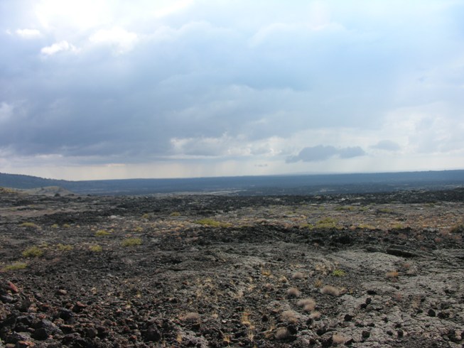
By the next morning, I was feeling better and decided to fix the trailer myself, and cancel the CW appointment.  So we returned to get the trailer (no one had stolen it), hitched, spoke with Helen and we were happy to hear she was home and resting comfortably, and cancelled my Tuesday appointment with CW.  On we drove toward Craters of the Moon, and tonight we are overnighting in Idaho near Declo, right on the Snake River.  Liz and I took a walk down to pretty park along the river. 

Our campsite is lovely--grassy areas in between each campsite, and extra wide sites.  It is a Good Sam RV park called Village of the Trees Resort, which also has a grill onsite which will deliver food to your site (we had leftover buffalo, etc.).

Friday, September 21, 2012

Canyonlands National Park


The morning showed the RV still with power, so the new battery may be doing the trick.  Helen was going to stay at the trailer and lay down, but I told her she could recline in my (driver's) seat when Liz and I were hiking, and perhaps that would help allowing her to still see the sights from the car.  She decided to go with us, and off we headed to Canyonlands National Park.

The first stop was at the Monitor and Merimac--two red monolithic rock formations named after the civil war ships, and the immensity of the canyons only grew as we climbed higher and higher up on a vast plateau formed between the Green and Colorado Rivers.  Deep, sheer canyon walls dropped away from the pleateau--carved by the forces of water over the eons.


 We were able to take several easy hikes, leaving Helen behind to rest near the car, to see these gorgeous vistas, as well as a natural arch window that kept opening onto a sensational canyon view as you approached.


Some of the scenic pullouts were right at the road's edge, and Helen could get out and enjoy the beauty without walking more than a few steps.  On one, we looked back at a landscape that seemed to have been ripped from Mars, and at another, the awe of the canyon was easly seen.  Once, we stopped where a raven chortled at us, and I told him that he needed to visit his friends in Mendocino if he wanted better pickins'...

We decided to stop for lunch at the picnic area near the end of the overlooks, and these lovely picnic spots have tables under shade canopies, and each picnic table has a paved parking space slotted in diagonally in front of it--the tables are set fairly far apart, so there is a sense of privacy.  We pulled in to the slot for the picnic table, Liz got out, walked over to the table, and pronounced it a good one before heading off to the restroom, while Helen and I began to unload.  As we approached our table, a young woman, one of the many foreign tourists (French in this case), rushed over and took our table as we neared.  I told her we were in the tables parking slot and the table was ours, and she waved her hand and said "we come from just over there" which turned out to be about 200 yeards away at a trailhead, as she beckeoned the rest of her family who came quickly trotting up.  Lizzie later said she saw hur hurrying toward us, and thought she was trying to beat her to the restroom.  But no, she was stealing our table.  We told her she was very rude, got into the car, backed out of the parking space for that picnic area, picked up Liz, and headed to look for another spot, of which there was none. 

An hour later at the Dead Horse State campground down the road, 2:30, we had our picnic, still fuming over the rudeness of that young woman.

The Deadhorse State State Park is very beautiful, and is so-named because in the history of the area, cowboys once rounded up some horses, penned them, and left them without water.  They all died, thus giving the place its name.  Today, the visitor center has plenty of water, as well as a coffee stand, art gallery, and gift store--the staff are friendly, and well made trails wander around the canyon rim.  In the distance to the north were two enormous salt basins.  The picnic area is large and easily accessible, and like all picnic areas, full of hungry chipmunks.


Tomorrow the plan is to return to Arches, and then dine out on buffalo or other game at Buck's Grillhouse in Moab.

Thursday, September 20, 2012

Morning in the Moab ER

We started the day determined to take Helen to the Emergency Room at the brand new Moab hospital.  On Tuesday morning she had awakened after sleeping "wrong" with a very painful hip/back.  Learning that she had pain shooting down her leg and a numb toe or two, Liz and I insisted, and off we went to the ER.  She got in right away, had xrays, consulted with a wonderful young lady doctor, and off we went an hour-and-half later with the sciatic diagnosis.  Now we know what we should do to treat it.

Also, we awoke in the night (Wednesday night) tio the beeping of the converter indicating a low battery, despite being hooked up to power.  By morning, nothing registered on the battery indicator, wither connected or stand-a-lone.  This was despite our having power after hookup and during the night through the elctrical hookup as tested by a night light plugged into one of the AC receptacles.  Thinking I may have damaged the battery when i accidentally reversed polarity at Mendocino, I bought a new one while waiting for Helen to go in to the ER.  Tonight, the charge appears to be holding, we have power to to AC receptacles, and we'll see what the night brings. 

We started out at Arches National Park, a breathtaking NP that everyone should visit at least once.  Although it is quite warm--83 degrees  which is warm for us coastal folks--it cools down somewhat at night, making it comfortable to sleep without running the A/C.  The visitor center is interesting, and do listen to the film as it explains how the diverse forces of nature over the millions of years formed Archjes and Canyonlands.  Then, we seto out up the hill along with many others to explore this strange and beautiful area.

Balancing rock represenbts a photographer's dream, and one can walk all around it, viewing the unusual rock formation from all angles.  We expect that the lighting as it changes the shadows throughout the day would also change what we saw.

Helen stayed near the parking area with many others--including at least twelve Cruise America RVs filled with a group of travelling Dutch folks as one large group.   Liz and I walked completely around the red rock formation.  It is an easy walk, and not to be missed.

Another rock formation we drove by reminded us of Queen Nefertiti's head (below right), so we paused a moment to take a picture.  All of the rocks change their shape as you move around them, often appearing as animals, and people--even a red rock bigfoot jumped out at us as we travelled on.


Liz and I walked up a small, narrow path to view Sand Arches--the trail passes through close sided sandstone walls, and opens onto a red grotto, lit from the sunshine above, before continuing on to the natural rock arch.  The pcitures are below.


We finished the day hiking to the arch known as "Skyline Arch" and again Helen waited for us as her back/hip was bothering her alot.